Posts

Showing posts from February, 2021

I *glove* you

Image
 Forecast update Sunday has a high of 30 and a low of 16.

oh *snow*!

Image
 Forecast update: Northwest flow continues to the area until Sunday bringing snow on Saturday with 2 to 4 inches of snow possible. Saturday has a high of 18 and a low of 14. Sunday has a high of 30 and a low of 18.   

Some guy I know from school just brushed past me without a skiing jacket on. I think he was giving me the cold shoulder.

Image
 Forecast:  A high pressure ridge and cold front coming through the area bringing some snow to the area. Friday will have a high of 18 and low of 10 with 3 to 8 inches of snow. Saturday high of 22 and low of 12 with new snow of 1 to 3 inches. Sunday has a high of 28 and low of 16. 

During ski season, I try to keep a *snow* profile.

Image
 Forecast update.  Trough continues in brings chance of snow for Monday with a high of 32 and a low of 18. up to 4 inches of snow is possible. 

That slope was so easy, it was a real *piste* of cake.

Image
 Forecast update Northwest flow aloft continues to bring moisture in the form of snow into the area. Sunday has a high of 30 and a low of 26 with 4 inches of snow expected. Monday has a high of 36 and a low of 24.  

There's a whole lot of *glove* here.

Image
 Forecast update: Warm front moves through area bringing warmer temps to the area. 

OK, *icy* what you did there.

Image
   Forecast update Trough continues to bring moisture into area with the chance of snow . Friday has a high 28 and a low of 16 with snow of 1 to 2 inches. Saturday has a high of 24 and a low of 16. Sunday has a high of 30 and a low of 24, Monday will be warmer with a high of 34 and a low 24. 

time to be in the *snow* how

Image
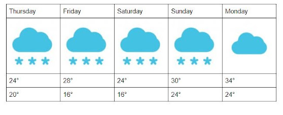
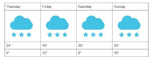
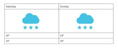
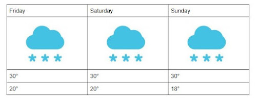
 A trough is bringing moisture into area with the chance of snow. Thursday (today)  will have a high of 24 and a low of 20 with total snow of 2 to 8 inches possible. Friday has a high 28 and a low of 16 with snow of 1 to 2 inches. Saturday has a high of 24 and a low of 16. Sunday has a high of 30 and a low of 24, Monday will be warmer with a high of 34 and a low 24. 

If we do say *snow* ourselves

Image
 Low pressure trough moves with a south west flow. It will push moisture east in the form of snow! Saturday has a possibility of 3 to 5 inches of snow. Sunday has a possibility of 3 to 7 inches of snow. 

*Ski* ya later

Image
 Forecast update: Chance of snow Friday with up to 4 inches and high of 20 and 12. Saturday has snow of up 5 inches a high of 20 and a low of 7. Sunday has a high of 24 and a low 14. 

Can *Alp* you?

Image
 Arctic air comes through the area and will bring snow and cold air. On Saturday will come in and bring more snow to the area. Thursday has a high of 24 and a low of 8 with a chance of up to 4 inches of snow. Friday has a high of 16 and a low of 12 with 3 to 6 inches of snow. Saturday has a high of 20 and a low of 8 and 3 to 7 inches of snow. Sunday has a high of 20 and a low 15.

I came, I *thaw*, I conquered

Image
 Sunday has a high of 24 and a low of 10.

Its a *winterful* life

Image
 Forecast Update Saturday and Sunday both have chances of snow. Saturday has a high of 30 and low of 18. Sunday has a high of 24 and a low of 18.

Powder to the people

Image
 Forecast update: Friday has a chance of 3 inches of snow with a high of 30 and low of 20. Saturday has a of 30 and low of 20. Sunday has a high of 30 and low of 18.

It takes one to snow one.

Image
 A trough will be moving eastward into the area bringing moisture. There is a possible chance of snow Thursday through Sunday. Most of the accumulation will be Thursday and Friday with 2 and 3 inches of possible accumulation respectively. Thursday has a high of 30 and a low of 24.  Friday and Saturday both have a high of 30 and a low of 20. Sunday high 30 of low of 18.