Forecast: trough moves in on Monday bringing snow. The backside of the trough clears Tuesday up. Another trough will move in Wednesday and stay through Thursday. High pressure will come in Friday clearing the day up.
Saturday a weak trough moves through bringing possible snow. The trough will continue east on and clearing Sunday a little bit. More snow can be expected on later dates throughout the week.
High pressure ridge remains through Thursday will be a bit warmer and sunny, a low pressure trough moves in Friday and will persist until Tuesday. This will bring snow to the area for some of the days.
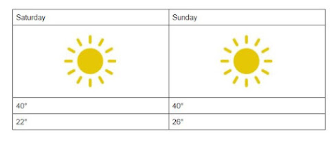
Forecast update Sunday will likely have more clouds due to the lower pressure that shifted into the area. A cold front will move into the area bringing snow for the night. Sunday has a high of 40 and a low of 26.
Forecast: A ridge will bring drier air and clear the region up through Saturday. A cold front will move through the area Sunday bringing a chance of snow for Sunday.
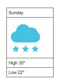
Forecast update: A cold front and a trough bringing moisture to the region. Saturday has a high of 30 and a low of 18 with a chance of snow. Sunday has a high of 30 and a low 22 with a slight chance of snow.
Forecast Update: Friday has a high 40 and a low of 24 and will be sunny. Saturday has a 30 and a low of 18 with a chance of snow. Sunday has a high of 32 and a low of 22 and will be partly cloudy.
Forecast: Thursday has a high of 38 and a low of 22. Friday has a chance of snow with a high of 40 and a low of 24. Saturday has a high of 28 and a low of 16 with a chance of snow. Sunday has a high of 32 and a low of 20 with a chance of snow.